Hamlin Street Over Acushnet River Bridge Replacement

HAMLIN STREET OVER ACUSHNET RIVER BRIDGE REPLACEMENT
Project No. 600645
Bridge No. A-03-003, A-03-007, AND A-03-008
PROJECT LOCATION
The project is located in the southwest quadrant of Acushnet. Hamlin Street extends easterly from the intersection with Middle Road to the intersection with Main Street. The proposed project begins at a point located approximately 0.45 miles east of the intersection with Middle Road and extends east along Hamlin Street approximately 530 ft. over the Acushnet River to a point located approximately 0.65 miles west of the Hamlin Street intersection with Main Street.
PROJECT PURPOSE
The purpose of the project is to increase the load capacity of the existing crossing, widen the bridges over the crossing to meet current traffic safety standards and to match the existing approaches, and improve mobility for all users.
EXISTING CONDITIONS
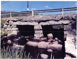
Hamlin Street is a two-lane (one each direction) local roadway. Traffic volume on Hamlin Street is relatively low (estimated to be 2,600 vehicles per day). There are three existing buried stone masonry structures within the project length. The easterly structure (A-03-003) crosses the main channel of the Acushnet River. The middle structure (A-03-008) is located approximately 105 ft. to the west in the overbank area of the river. The middle structure has a stone weir across the upstream end. The top of the weir is just below the I0-year discharge water surface elevation and under normal low flow conditions passes some small amount of flow due to leakage through the upstream end stone weir. The westerly structure (A-03-007) is located another 170 ft. west in the overbank area of the Acushnet River. The westerly structure inlet elevation is above the JO-year design discharge elevation and approximately 1.2 ft. above the I00-year base flood elevation.
The main river channel crossing (A-03-003) is currently load posted to a weight limit of just 3 tons due to the structural condition of the structure. The bridge inspection documents cracks in the stone span superstructure. All of the bridges are narrower than the approach roadway. The existing two-lane paved roadway is generally 20 ft. wide and narrows slightly to approximately 18 ft. over the existing structures with no shoulders and no sidewalks.
Development along Hamlin Street is residential, and a historic property (White's Factory ruins) located on the Fairhaven Land Preservation Trust property abuts the project along the southeast approach. An existing gravel parking area providing access to the site is located near the southeast limit of the proposed project. The immediate surrounding area is mostly undeveloped open space and wetlands extend out from the toe of the existing roadway embankment for nearly the full length of the project on both sides of the roadway. At the north side the roadway, the project runs along the former "Hamlin Pond" area and mostly along the land of the Town of Acushnet Park Commission. A small parking area with access to the river is located at the northeast corner of A-03-003, and a private drive is located at the southeast corner of A-03-003 and near the east end of the proposed project limit. The surrounding area is suburban and consists of lightly developed residential properties.
The existing alignment through the project is generally on a horizontal tangent between "S" shaped curves with the main crossing being on an existing 450 ft. radius horizontal curve. To the west of the project, there is a 600 ft. radius curve. The vertical alignment is on relatively flat grades of less than l %. The posted speed on Hamlin Street is 30 mph. The existing two-lane paved roadway is 20 ft. wide and narrows to 18 ft over the existing structures with no shoulders and no sidewalks. There are short sections of guardrail or fence at each of the bridge locations.
The existing three stone masonry structures are similar two-span buried structures with stone masonry slab spans supported on stone masonry abutments. The clear spans vary from approximately 3.5 ft. to 9.5 ft. and bridge lengths vary from approximately 12 ft. to 21 ft. The main channel crossing (A-03-003) has clear spans of approximately 9.5 ft. and 9.0 ft. and a bridge length ofapproximately21 ft. The date of construction of the structures is unknown, but likely pre-I 9th century. The clear roadway width of the existing bridges varies some at each crossing and is approximately 17 ft. to I8 ft. wide. There are no sidewalks in the existing roadway approaches or on the existing structures. The existing structures do not meet current legal load standards and are posted (3 tons).
PROPOSED IMPROVEMENTS
The Massachusetts Department of Transportation (MassDOT) proposes to replace the Hamlin Street crossing of the Acushnet River in Acushnet. The proposed bridge project consists of the replacement of the existing easterly (A-03-003) and middle (A-03-008) stone masonry structures and removal of the existing westerly structure (A-03-007). A retaining wall will be placed near the existing downstream end of A-03-007, and the wall will include an architectural finish that replicates the original pre-existing stone masonry crossing. The improvements also include widening of the roadway over the proposed structures and the addition of a sidewalk along the south side of the roadway. The proposed new easterly crossing will be a 42-foot single span precast prestressed concrete voided slab beam bridge superstructure supported on cast-in-place reinforced concrete cantilever wall abutments founded on steel
H-piles. The existing middle structure (A-03-008) will be replaced with an 8 ft. clear span precast concrete box culvert with a weir structure at the inlet end that will mimic the existing conditions. The overbank structure will provide hydraulic relief during high flow events. The proposed bridges will have a 26 ft. curb to curb roadway width providing two IO ft. wide vehicular traffic lanes with a 4 ft. wide westbound shoulder and 2 ft. wide eastbound shoulder and a 6 ft. wide sidewalk on the south side of the roadway.
The proposed approach roadway will closely follow the existing horizontal roadway alignment with a curved offset alignment to the north to accommodate the widening and existing roadway alignment at the project limits. The proposed roadway profile will closely follow the existing roadway profile. The proposed approach roadway work includes the construction of approximately 480 feet of approach roadway and begins approximately 120 ft. west of the existing westerly crossing (A-03-007) and ends approximately 80 ft. east of the existing easterly structure (A-03-003). The proposed approach roadway will be widened to 26 ft. to meet current roadway traffic safety standards and will taper to match the existing approach roadway at each end of the project. There will be one 6 ft. wide sidewalk on the south side of the proposed bridges and approach roadway. The project will include the relocation of several utilities.
UTILITIES
Existing overhead electric, telephone and cable lines run along the north side of Hamlin Street and through the proposed project. A buried municipal water line is located generally along the south side of the existing roadway. The buried water line was reportedly installed using directional drilling and passes below the existing structures. Electric and telephone lines through the project will be removed with service being provided at each end. Cable will be relocated underground between existing poles located just outside the project limits. The existing buried water line will be relocated. The proposed relocated water line will be on the south side of the road and will tie into the existing facilities near the ends of the proposed project. Over the crossings, it will be supported by the proposed structures and beyond the structures will be located below the proposed sidewalk on the south side of the roadway.
RIGHT OF WAY IMPACTS
Permanent right of way takings, one permanent easement, and several temporary easements are required for the project. The City shall obtain the necessary permanent takes, permanent easements, and temporary construction easements required for the project. Four (4) permanent takes are required from the abutting properties to construct and maintain the proposed widened roadway embankment, to relocate an existing balanced stone wall, to construct and maintain proposed Bridge Nos. A-03-008 and A-03-003, and to construct and maintain guardrail. One permanent easement is required from an abutting property to construct and maintain roadway slopes and riprap revetment. Four (4) temporary construction easements are needed for construction access, slope work, and drive work.
ENVIRONMENTAL
The project, as currently designed, will result in impacts to Waters of the United States, thereby necessitating the preparation of a Section 40I Water Quality Certificate and a Section 404 Army Corps of Engineers (ACOE) Applications to be filed with the Massachusetts Department of Environmental Protection and ACOE with MassDOT as the proponent. Footprint impact areas are minimized by using a reduced berm offset behind guardrail and I.SH: IV riprapped slopes at the abutments and along the north side of the roadway embankment.
MAINTENANCE OF TRAFFIC DURING CONSTRUCTION
The crossing will be closed during construction. Traffic and pedestrian access will be maintained with a temporary detour. Starting at the west end of the project on Hamlin Street, the proposed detour will follow Hamlin Street west to Middle Road south, continue south on Belleville Avenue, and continue east and north along Main Street and west along Hamlin Street to the east end of the project. Total detour length is approximately 5.3 miles. Access to homes along Hamlin Street will be maintained at all times with the temporary detour in place. The temporary detour roadway is anticipated to be in place for a duration of approximately seven (7) months beginning in early spring of2020 and extending to the fall of 2020.
PROJECT COST
The preliminary construction cost estimate for this project is approximately $1.3 million.
PROJECT STATUS
The design plans presented here represent the 25% Design. Comments made at this public hearing will be considered in developing the final design documents. The project is currently scheduled to be advertised for construction in October of 2019 and construction is anticipated to extend into the fall of 2020.
| Attachment | Size |
|---|---|
| 1.37 MB |